Plot size diagram
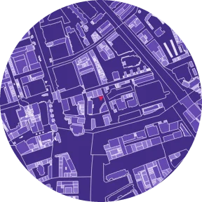
The PLOT SIZE plate colours the parcels of the Kadaster cadastral map in 5 bands by area.
Updated 15 October 2026This page was written by AI.
Overview
CADASTRAL PARCELS draws parcel outlines as lines. PLOT SIZE colours the same parcels by area, so that finely divided land and large single parcels can be told apart at a glance. Plot size is the size of the development unit: areas of 100 m² parcels and areas of 3,000 m² parcels differ in the buildings that fit and in how change happens.
How to use
- Compare the band of the site with the bands around it
- See which band dominates: small parcels mean change parcel by parcel; large parcels mean single schemes
- Look at edges where the band changes sharply
Method
| Item | Content |
|---|---|
| Data | Kadastrale kaart (cadastral map), Kadaster, CC BY 4.0 |
| Area | Measured from the parcel outline in RD New (EPSG:28992) |
| Bands | 100 · 300 · 1,000 · 3,000 m² (5 bands) |
| Note on the plate | Number of parcels, median area and band limits |
The bands are the same as in the other editions. They are not a planning threshold.
The «Site overview» shows the registered area (kadastrale grootte) of the parcels you pick, which can differ from the measured outline. See Site overview.
Limitations
- The cadastral map represents the register. Parcel lines are not fixed legal boundaries and not a survey
- Apartment rights (appartementsrechten) divide a building, not the parcel; they are not shown
- The plate does not show ownership. Neighbouring parcels with the same owner are not merged
Data sources
- Kadaster, Kadastrale Kaart (CC BY 4.0)
Related guides
© sitedia · Home · About · All guides · Pricing ·
Terms · Privacy · Contact · Data sources ·
Other editions: Korea · United States · Japan · Spain · United Kingdom
Example plates: BAG (Kadaster, CC0) · © 3DBAG by tudelft3d and 3DGI (CC BY 4.0) · BGT, NWB, AHN4 (CC0) · Kadaster, Beeldmateriaal.nl, PDOK (CC BY 4.0) · © OpenStreetMap contributors (ODbL)
Example plates: BAG (Kadaster, CC0) · © 3DBAG by tudelft3d and 3DGI (CC BY 4.0) · BGT, NWB, AHN4 (CC0) · Kadaster, Beeldmateriaal.nl, PDOK (CC BY 4.0) · © OpenStreetMap contributors (ODbL)