Trees
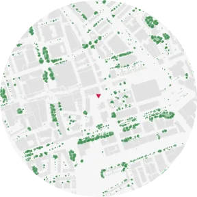
The TREES plate detects tree crowns from the 2025 near-infrared aerial photo and AHN4 heights, and draws them as individual trees and continuous canopy.
Overview
GREEN SPACE & WATER draws areas from the BGT: it shows land cover, not where the trees are, and it does not include street trees. TREES detects vegetation that is green in the near-infrared photo and stands at least 2 m above the ground.
Method
| Item | Content |
|---|---|
| Aerial photo | PDOK Luchtfoto CIR (near-infrared), 25 cm, summer 2025 flight (Beeldmateriaal.nl, CC BY 4.0). The 8 cm spring 2026 photo is not used because trees have no leaves on it |
| Vegetation | NDVI (near-infrared against red) above 0.25, after an offset measured on the ground in each scene |
| Height | AHN4 surface minus ground (DSM − DTM) of at least 2 m |
| Masks | Buildings and water are removed |
| Drawing | Dense crowns as continuous canopy (area), the rest as individual trees |
Low green that fails the height test (grass, gardens, fields) is drawn on GREEN SPACE & WATER as «Green space and low vegetation».
Check against municipal tree registers
Share of trees in the municipal tree registers that have a detected crown within 3 m (800 m radius): Delft 76.4%, Rotterdam 84.4%, Amsterdam 84.1%. Young trees under 6 m are found less often (51%). Canopy cover within 800 m: TU Delft BK City 15.7%, Rotterdam 16.4%, Amsterdam 11.0%.
Limitations
- The plate shows crowns, not a tree count
- Tall hedges and climbing plants on walls over 2 m can be counted as trees
- Trees felled or planted after summer 2025 are not shown; AHN4 heights date from 2020–2022
- The first plate for a new place takes about 40 seconds because the photo and heights are fetched for that site
Data sources
| Data | Use |
|---|---|
| Beeldmateriaal.nl, Luchtfoto CIR 2025 (CC BY 4.0), via PDOK | Vegetation |
| AHN4 (CC0) | Height above ground |
| BAG, BGT (CC0) | Building and water masks |
Related guides
Example plates: BAG (Kadaster, CC0) · © 3DBAG by tudelft3d and 3DGI (CC BY 4.0) · BGT, NWB, AHN4 (CC0) · Kadaster, Beeldmateriaal.nl, PDOK (CC BY 4.0) · © OpenStreetMap contributors (ODbL)