AHN4, NAP and contours
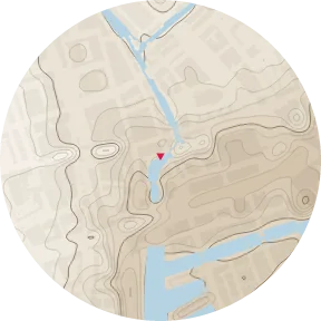
How the TERRAIN & CONTOURS plate draws ground height from AHN4 relative to NAP, how the contour interval is chosen, and how relief is measured on flat ground.
Overview
AHN (Actueel Hoogtebestand Nederland) is the national elevation model, measured by airborne laser scanning. AHN4 was surveyed 2020–2022. sitedia uses its ground model (DTM, maaiveld), with buildings and vegetation removed. Heights are given relative to NAP (Normaal Amsterdams Peil), the Dutch vertical datum; much of the western Netherlands lies below 0 m NAP.
Method
| Item | Content |
|---|---|
| Data | AHN4 ground model (DTM, 0.5 m), fetched in 2 km tiles and averaged to 5 m |
| Gaps | Gaps under buildings are interpolated from the surrounding ground. Only over wide water and outside the country is Copernicus DEM GLO-30 used |
| Height reference | NAP |
| Contour interval | Chosen from the relief inside the circle (1st to 99th percentile) so that there are at most about 14 contours, starting at 0.5 m |
| Note on the plate | Interval and relief, for example «Contours every 0.5 m above NAP · relief 4.6 m» |
Sample sites (800 m radius)
| Site | Ground height (1st–99th percentile) | Relief | Interval |
|---|---|---|---|
| TU Delft BK City | −1.93 to 2.63 m NAP | 4.6 m | 0.5 m |
| Amsterdam, Academie van Bouwkunst | −0.20 to 2.93 m NAP | 3.1 m | 0.5 m |
| Rotterdam, Academie van Bouwkunst | −2.15 to 4.61 m NAP | 6.8 m | 0.5 m |
In places with more relief the interval grows: 1 m in Almere, 2 m in Maastricht and Nijmegen.
Why the 1st to 99th percentile
A single dyke top, quay or leftover building edge would otherwise set the relief. The percentile range describes the ground most of the circle stands on.
Limitations
- Earthworks after 2022 are not included
- The 5 m grid flattens narrow features such as ditch banks
- The plate is not a survey; levels for design, drainage and floor heights need measured data
Data sources
- AHN4 (Actueel Hoogtebestand Nederland), CC0 · wide water: Copernicus DEM GLO-30 (© DLR e.V., © Airbus Defence and Space · ESA)
Related guides
Example plates: BAG (Kadaster, CC0) · © 3DBAG by tudelft3d and 3DGI (CC BY 4.0) · BGT, NWB, AHN4 (CC0) · Kadaster, Beeldmateriaal.nl, PDOK (CC BY 4.0) · © OpenStreetMap contributors (ODbL)